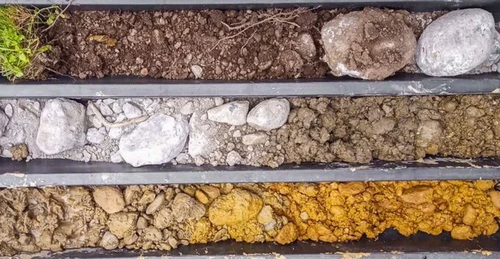
We have seen projects across Concord stall because the owner relied exclusively on borings without ground-truthing the upper five to ten feet. A single geotechnical boring every thousand square feet can easily miss a backfilled creek channel or a pocket of uncontrolled fill that settled decades ago. In the clay-rich alluvium of the Ygnacio Valley and the weathered sandstone of the Lime Ridge foothills, an exploratory test pit opens a continuous window into the shallow subsurface that no split-spoon sampler can replicate. Our team excavates each pit to the depth specified in the scope, logs the profile using the ASTM D2488 visual-manual procedure, and collects representative bulk samples for laboratory index testing. When the pit exposes undocumented debris, organics, or perched groundwater, the field engineer can adjust the sampling plan immediately rather than waiting for lab results that arrive too late to change the excavation sequence. For deeper stratigraphic control below the test pit depth, we often pair the excavation with an SPT drilling program that extends the profile to bearing depths required by the structural engineer.
A well-logged test pit in Concord's alluvial basin reveals more about the shallow fill history than a dozen SPT blows ever will.
Local ground factors
Concord recorded a population of roughly 125,000 in the 2020 census, and much of the housing stock built after the 1950s occupies land that was previously agricultural or open grazing. That land-use history means buried irrigation lines, old stock ponds, and uncompacted lean clay fill are common across the Monument Boulevard corridor and the neighbourhoods east of Highway 242. An exploratory test pit that misses a two-foot lens of saturated silt can lead to differential settlement that cracks slab-on-grade floors within the first five years of occupancy. The risk is amplified where the native Ygnacio formation clay grades laterally into colluvial deposits shed from Mount Diablo; the contact between the two materials can concentrate groundwater flow and create a softened zone that a standard boring log would average out over a 1.5-foot split-spoon interval. By opening a continuous face, the test pit allows the engineer to trace that contact across the full excavation width, measure its dip, and recommend either over-excavation or a geogrid-reinforced fill section before concrete is poured.
Common questions
What is the typical cost of an exploratory test pit in Concord, California?
For a single pit excavated to 10 feet in accessible soil, the cost generally falls between US$470 and US$890. The final figure depends on how many pits are requested, the depth required, whether traffic control or pedestrian barricades are needed, and how much laboratory testing is specified on the bulk samples collected from the pit.
Which ASTM standard governs the logging of an exploratory test pit?
ASTM D2488 is the primary standard used for visual-manual description of soil in the field. The group symbols and names reported on the log are assigned per ASTM D2487, which defines the Unified Soil Classification System. Both standards are referenced in the geotechnical report issued after the fieldwork.
How deep can you excavate a test pit in Concord's soil conditions?
Practical depth is usually 10 to 14 feet with a standard backhoe arm. In the stiff clay and weathered sandstone typical of the Lime Ridge and Treat Boulevard areas, the bucket can reach the upper limit of the decomposed bedrock, at which point a drilling rig becomes more efficient for deeper investigation.
Is a test pit sufficient for a foundation design submittal to the City of Concord?
A test pit provides excellent shallow-subsurface data, but the building department will also require deeper exploration through borings or CPT soundings when the structural load exceeds the bearing capacity of the near-surface soils. The test pit log is submitted as part of the overall geotechnical report and is particularly useful for documenting fill removal and re-compaction.